Property Record
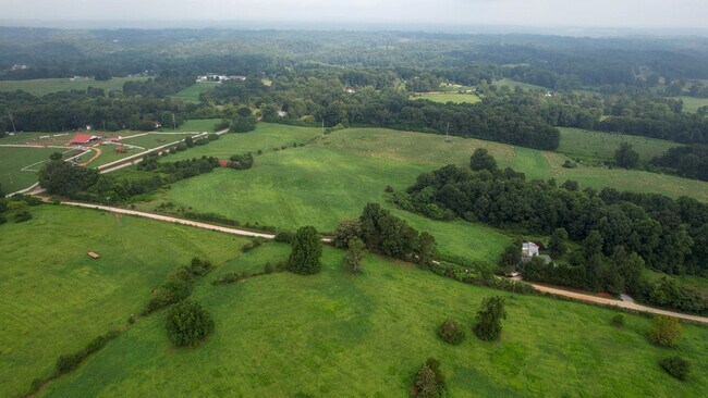
Ga Highway 365, Alto, GA 30510
NEARBY LISTINGS FOR SALE OR LEASE
-
-
View all Alto listings for sale on LoopNet.com
Property Detail
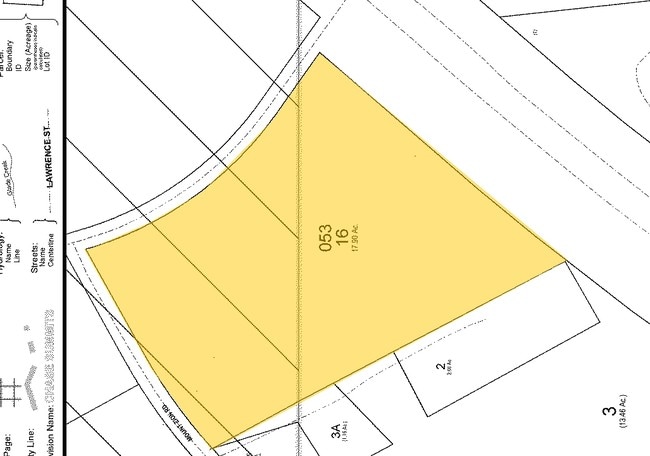
Ga Highway 365
053-016A
10-164 ALTO MUD CR DB 1293-470
Residentialacreage
Habersham
AE
Georgia
13137C0276D
67.20 AC
2025
Georgia Northeast
2025
Other Market Areas
000601
Cornelia, GA
DEMOGRAPHICS near Ga Highway 365
1 Mile
3 Mile
5 Mile
2024 Total Population
865
8,506
18,700
2029 Population
937
9,351
20,669
Pop Growth 2024-2029
+ 8.32%
+ 9.93%
+ 10.53%
Average Age
37
39
38
2024 Total Households
176
2,522
6,096
HH Growth 2024-2029
+ 10.23%
+ 10.47%
+ 10.66%
Median Household Inc
$54,565
$54,327
$49,658
Avg Household Size
2.90
2.80
2.70
2024 Avg HH Vehicles
2.00
2.00
2.00
Median Home Value
$127,551
$153,851
$156,821
Median Year Built
1996
1994
1992
Nearby Places
Map Layers
Map Styles
 Street
 Aerial
- Restaurants
- Banks
- Shops
- Fitness
- Groceries
SALE & LEASE HISTORY
LISTING DATE
SALE/LEASE

Aug 04, 2021
For Sale
Nearby Properties
Address
Land Use
TOTAL SIZE
Lot Size
Zoning
Address
Land Use
TOTAL SIZE
Lot Size
Zoning
21,000 SF
28.32 AC
ARR
Address
Land Use
TOTAL SIZE
Lot Size
Zoning
11,776 SF
34.53 AC
HI
Address
Land Use
TOTAL SIZE
Lot Size
Zoning
451,247 SF
98.29 AC
M1
Address
Land Use
TOTAL SIZE
Lot Size
Zoning
152,186 SF
19.81 AC
HI
Address
Land Use
TOTAL SIZE
Lot Size
Zoning
161,855 SF
26.12 AC
HI
Address
Land Use
TOTAL SIZE
Lot Size
Zoning
35,874 SF
4 AC
HI
Address
Land Use
TOTAL SIZE
Lot Size
Zoning
74,565 SF
7.80 AC
HB
Address
Land Use
TOTAL SIZE
Lot Size
Zoning
8,235 SF
5.01 AC
HB
Address
Land Use
TOTAL SIZE
Lot Size
Zoning
45,064 SF
27.23 AC
HB
Address
Land Use
TOTAL SIZE
Lot Size
Zoning
137,296 SF
23.65 AC
I
Address
Land Use
TOTAL SIZE
Lot Size
Zoning
82,942 SF
7.79 AC
HI
Address
Land Use
TOTAL SIZE
Lot Size
Zoning
90,350 SF
19.31 AC
HB
Address
Land Use
TOTAL SIZE
Lot Size
Zoning
54,000 SF
9.75 AC
HI
Address
Land Use
TOTAL SIZE
Lot Size
Zoning
39,840 SF
3.77 AC
HI
Address
Land Use
TOTAL SIZE
Lot Size
Zoning
39,110 SF
5 AC
HI
Address
Land Use
TOTAL SIZE
Lot Size
Zoning
20,625 SF
5.57 AC
HI
Address
Land Use
TOTAL SIZE
Lot Size
Zoning
11,700 SF
1.55 AC
HI
Address
Land Use
TOTAL SIZE
Lot Size
Zoning
18,103 SF
1.26 AC
B2
Address
Land Use
TOTAL SIZE
Lot Size
Zoning
96.89 AC
HI
Address
Land Use
TOTAL SIZE
Lot Size
Zoning
56,657 SF
8.61 AC
I
Address
Land Use
TOTAL SIZE
Lot Size
Zoning
20.98 AC
LI
Address
Land Use
TOTAL SIZE
Lot Size
Zoning
41,800 SF
3.20 AC
I
Address
Land Use
TOTAL SIZE
Lot Size
Zoning
2,448 SF
158.96 AC
LI
Address
Land Use
TOTAL SIZE
Lot Size
Zoning
204.99 AC
ARR
Address
Land Use
TOTAL SIZE
Lot Size
Zoning
9,625 SF
20 AC
LI
Address
Land Use
TOTAL SIZE
Lot Size
Zoning
6,050 SF
1.50 AC
HI
Address
Land Use
TOTAL SIZE
Lot Size
Zoning
5,880 SF
5.36 AC
HI
Address
Land Use
TOTAL SIZE
Lot Size
Zoning
5,152 SF
21.26 AC
HI
Address
Land Use
TOTAL SIZE
Lot Size
Zoning
10,210 SF
5 AC
C2
The World's #1 Commercial Real Estate Marketplace
Connect with us
© 2026 CoStar Group
The information above has been obtained from sources believed reliable. While we do not doubt its accuracy we have not verified it and make no guarantee, warranty or representation about it. It is your responsibility to independently confirm its accuracy and completeness. Any projections, opinions, assumptions, or estimates used are for example only and do not represent the current or future performance of the property. The value of this transaction to you depends on tax and other factors which should be evaluated by your tax, financial, and legal advisors. You and your advisors should conduct a careful, independent investigation of the property to determine to your satisfaction the suitability of the property for your needs.